Reading the Bathtub Ring: How a Dam Wall Keeps a Decade of Weather on Record
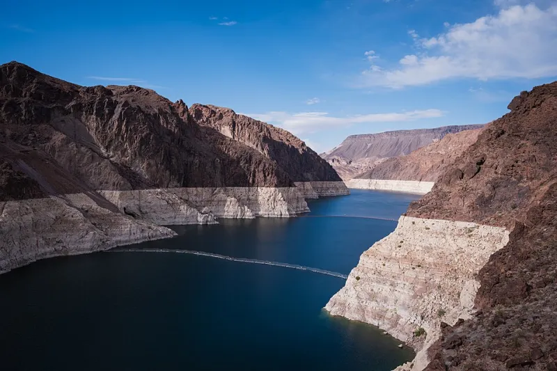
Photo: Christian David, CC BY-SA 4.0, via Wikimedia Commons
Drive across nearly any large dam in the American West — Mead, Powell, Oroville, or the modest flood-control reservoir outside your own town — and you'll notice the same thing: a pale, ghostly band of rock or concrete ringing the waterline, sometimes hundreds of feet tall. Locals call it the bathtub ring. Hydrologists call it something closer to a data set.
Because that's what it is. The ring is a chart of the reservoir's history, drawn automatically, requiring no instruments and no maintenance. Once you know how it forms, you can read a rough version of it yourself.
How Water Writes on Stone
The ring exists because reservoir water is not chemically neutral. It carries dissolved minerals — calcium carbonate being the big one in most western waters — plus suspended silt and clay. Where water meets the wall, two things happen over time.
Minerals precipitate out and coat the surface in a light-colored crust, the same chemistry that leaves scale in a kettle or a whitish film on a shower door. Meanwhile, silt settles and stains the zone a slightly different tone than the rock above or below. Either way, the submerged band ends up visually distinct: lighter, smoother, mineral-bleached.
When the water level drops, that band is exposed. The top edge of the ring marks the highest the water has sat for a sustained period. The current waterline marks where it is now. Everything in between is an inventory of what's been lost — or, in a good year, what's been temporarily hidden again.
The Tree-Ring Trick
The comparison to tree rings isn't a metaphor; it's nearly a method.
A tree adds a wide, pale ring in a generous growing year and a narrow, dark one in a stressful year, and because the rings are laid down in sequence, you can count backward through time. Reservoir rings are coarser — water levels fluctuate too much for neat annual bands — but the principle holds. A thick, high ring means years of sustained high water. A ring that sits far above the current surface, with a long bleached gap in between, records a drought and how deep it went.
Researchers do this quantitatively. Sediment cores pulled from reservoir bottoms contain layered deposits whose composition tracks flood years versus dry ones — coarse sand from big inflow events, fine clay from calm, low-water stretches. Combined with the exposed mineral bands and old stage records, scientists can reconstruct a water history for a basin going back decades. At Lake Mead, the ring that emerged during the post-2000 megadrought became one of the most photographed pieces of climate data in the country — an infographic the size of a canyon wall.
You Don't Need Lake Mead
The same read works at whatever scale is near you.
The local reservoir. Next time you cross the dam on a road trip, look at the gap between the ring's top edge and the water. A gap of a few feet in October might be completely normal — reservoirs are drawn down for winter flood capacity. A gap that persists through spring, when snowmelt should be refilling things, is the meaningful signal.
The water tower or well tank. Smaller versions of the same staining show up on municipal tanks and even stock troughs — mineral lines marking high-water stands.
Your own kettle and toilet bowl. The scale line in a heavily used kettle is the same calcium carbonate chemistry, recording how often and how hard your tap water worked. It's the bathtub ring, miniaturized.
What the Ring Can't Tell You
One honest caveat: the ring records level, not supply. A reservoir can sit full while the snowpack that feeds it shrinks, and a wet spring can erase two dry years from view in a single season. The ring is a running total, not a forecast. That's why agencies pair the visual with stream gauges, snow telemetry, and groundwater wells — the ring is the most legible line of evidence, but rarely the only one.
Still, there's something worth appreciating in that. We spend a lot of energy building dashboards to track water. It turns out the water has been keeping its own records the whole time, in mineral and silt, on every wall it's ever touched. The bathtub ring is the rare data visualization that doesn't need a screen — just sunlight, a pullout on the highway, and a minute to look.